Santa Ana Wildlife Refuge

Image 10
The Santa Ana National Wildlife Refuge consists of a 2,080 acre wildlife refuge along the northern bank of the Rio Grande in Hidalgo County, Texas. The wildlife refuge was established in 1943 for the protection of migratory birds and to preserve a remnant of the subtropical Rio Grande Delta riparian forest. The lower coast riparian wetlands and river associated habitats in this subhumid to semiarid region may be better referred to as riparian corridors.
The Santa Ana Wildlife Refuge lies within three land grants: Agostadero del Gato (the Pasture of the Cat), Los Toritos (the Little Bulls), and Santa Ana. The majority is within the Santa Ana land grant, which was conveyed by the Mexican state of Tamaulipas to Benigno Leal on May 19, 1834.
The majority of this type of habitat had been lost due to clearing of the land for agriculture along the Rio Grande. Over 95 percent of the original habitat in the Lower Rio Grande delta has been cleared or altered. The Santa Ana Wildlife Refuge is a small remainder of the semitropical thorn forest that was once dominant along the river. The wildlife refuge is located at an ecological crossroads where subtropical climate, the gulf coast, Great Plains, and the Chihuahuan desert come together. This combination of climate, geology, vegetation, and wildlife creates tremendous biological diversity. Many bird species cross this refuge during migration from the Central and Mississippian flyways on their way to Central and South America. Nearly one half of the documented butterfly species in the United States have been found in the Santa Ana Wildlife Refuge.
In 1967 the refuge was designated a Registered Natural Landmark “because of its exceptional value in illustrating the natural history of the United States of America.”
This remnant of subtropical forest is surrounded by cleared agricultural land and is being approached by urban sprawl within the Lower Rio Grande valley. The refuge preserves habitat and protects some of the few ocelots and jaguarondis that remain within the United States. Over 33 species of mammals, 372 species of birds, 200 species of butterflies, and 34 species of reptiles have been recorded within Sana Ana. Santa Ana has over 450 plant species. It is the northernmost range of many tropical plants and also has many species from the temperate zone. Five different mini habitats correspond to slight elevation differences, soil types, and nearness to water in refuge lakes or the Rio Grande. (http://www.texasoutside.com/easttexas/SantaanaNWR.htm)
Urban Sprawl:
The Lower Rio Grande Valley National Wildlife Refuge is located in South Texas along 275 miles of the Rio Grande. The majority of the former thorn forest, resacas, freshwater ponds, and wetlands were cleared in the early 1900s for farming and ranching. These same areas are now being utilized for urban and industrial development. The wildlife refuges were begun in the 1940, but it became obvious that the refuges by themselves were not sufficient to ensure the survival of the animal and plant communities along the river.
The biological diversity of the Lower Rio Grande Valley is now threatened by rapid growth, urban sprawl, and habitat fragmentation. In the recent past, some wildlife was supported on the ranches and farms. These ranches and farms are now being replaced by residential housing, manufacturing facilities, and transportation/storage warehouses. This has further limited the habitat available to wildlife. The expansion of cross-border trade has been in part due to the passage of the North American Free Trade Agreement.
Currently, there are 21 animal and plant species that are threatened or endangered in the Lower Rio Grande Valley. There are 35 more species the Texas Parks and Wildlife Department consider to be threatened. (http://www.texas sierraclub.org/press/special.pdf)
The ongoing effort of the United States Fish and Wildlife Service that began in 1978, has acquired more than 80,000 acres of land to protect and preserve habitat in the Lower Rio Grande Valley. The funding for this land acquisition has been through the federal Land and Water Conservation Fund. The Lower Rio Grande National Wildlife Refuge system protects more threatened and endangered species and species of concern than any other refuge or national park in North America. Therefore, land acquisition in the Rio Grande Valley has become a priority.
The Lower Rio Grande National Wildlife Refuge system is actually one of the success stories at this point. Nearly 40 percent of the wildlife refuges are surrounded by housing, agriculture, or industrial activities according to the non-profit National Wildlife Refuge Association (throughout the US, San Antonio Express-News: Knight Ridder/ Tribune Business News). These refuges have become habitat islands. About 20 percent of the refuges are less than 1,000 acres, which make them too small to be beneficial to many species and accomplish their goals.
It is estimated by the Brookings Institute that another 60 million homes and apartments will be constructed by 2030. The Rio Grande Valley is a good example of this urban growth. The McAllen-Edinburg-Mission metropolitan area is the fourth fastest growing area in the nation. The Brownsville-Harlingen-San Benito area is the 28th fastest growing metropolitan area according to the 2000 United States census.
Even with this urban expansion the area has endeavored to protect the natural habitat. This is partly accomplished because the area has recognized the economic impact of wildlife and conservation oriented tourism within the Rio Grande Valley. Bird watching and other wildlife oriented tourism has had a large economic benefit for the region. According to the McAllen Chamber of Commerce the economic impact of ecotourism in the Rio Grande Valley is about $125 million per year.
(http://www.redorbit.com/news/science/217920/havens_are_preserving_nature_and_boosting/)
Flooding:
In June of 2010, the Santa Ana National Wildlife refuge was flooded by high waters that resulted from Hurricane Alex. The extensive flooding resulted in many changes within the refuge. The refuge had been historically flooded for short durations by the Rio Grande. The flooding from the hurricane was unusual in its depth and duration. Many plants and animals did not survive the flooding, but others have thrived. The refuge personnel typically monitor changes within the refuge. Additional monitoring of the species present within the refuge followed the hurricane. The long term flooding appears to have been beneficial in the removal of invasive plants. (See Maps page for Flood Conditions)
Prior to the establishment of flood control dams along the Rio Grande, the river would periodically flood. These floods constantly changed the course of the Rio Grande and formed oxbow lakes, locally known as resacas. The management program at Santa Ana Wildlife Refuge attempts to mimic this natural flooding. This practice maintains the bottom land hardwood forest and provides nesting and feeding habitat for birds, water holes for animals, and habitat for many amphibians, reptiles, crustaceans, and insects.
The refuge pumps water from the Rio Grande to periodically change the water levels of the Resaca lakes. Periodically the resacas are allowed to dry out, and at other times they are flooded. This adjustment of water levels is to promote biodiversity. Low water levels benefit diving birds and encourage vegetation growth. Deeper water benefits different species. (http://www.themonitor.com/articles/growing-49022-refuge-santa.html)
Additional Article on Flooding:
http://www.srh.noaa.gov/bro/?n=2010event_riograndereduxseptoct
Flooding, Multi-Media (Youtube):
|
|
|
Habitat Corridors:
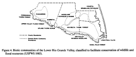
Image 8
In semiarid regions such as the Rio Grande valley, riparian corridors provide valuable habitat because the upland areas are typically not forested. The habitat provided by these riparian corridors provides an important boost to the regional economy through outdoor activities such as birdwatching.
Another of the threats to the narrow riparian corridors is their limited size. These narrow bands are very easily disturbed by overgrazing, channel dredging, and brush control programs. Channel dredging is done to stabilize the international border between Mexico and the United States. The brush control efforts and overgrazing tend to encourage invasive species such as salt cedar and mesquite. These two species use a lot of water and are targeted for removal by water conservation efforts. When salt cedar and mesquite dominate a riparian corridor, this mixture is less desirable than a mixture of native trees and brush species.
(http://www.texaswetlands.org/riparian.htm)
